History of the Wye Valley Railway
Investigation into change of route
Summary
There were several reasons for promoting a railway between Monmouth and Chepstow. Prior to opening the railway, freight from the industrialised Wye Valley and passenger traffic had to make a journey of 43 miles instead of 15 miles by the new route shortening the journey time by two hours. Tourists would be expected to be attracted to the beauty of the Wye Valley.
The 1866 Act of Parliament authorised a route along the west bank of the River Wye passing through Tintern. The 1874 route followed the east bank of the River Wye crossing the River north of Tintern then following the same route as authorised by the 1866 Act.
The original plans held by the Gloucestershire Records Office have been consulted and analysed. The only WVR board account we have found of the reason for changing the alignment simply states that the new route ‘would probably be more economical’.1

Fig 1: 1865 sketched route to Llandogo following the west bank of the river Wye
We have made comparisons between both plans and have come up with no clear-cut financial benefits but from a risk point of view we have found supporting evidence for the decision.
Investigations continue to locate contemporary evidence.
1865 route and 1874 route
Two principal documents were reviewed at the Gloucester Records Office.
1 The 1865 plan Ref Q/RUm/355 which was incorporated in The Wye Valley Railway Act 19 August 1866.
2 The 1874 plan Ref: Q/RUm/402/2 which was incorporated in the Wye Valley Railway Amendment Act 14 June 1875. The Records Office have noted on their file that this plan was
'[Carried out according to this plan except for branch line; 38-39 Vic., cap.51.] '
The route sketch to Llandogo that was included in the 1865 plans is shown in Fig 1.
From Tintern to Monmouth both the 1865 plan and the 1874 plan follow the same route.
In Fig 2 the 1865 line is coloured red and the as-built. 1874 line is in faint black and white. Two tunnels are marked on the 1865 line. Fig 2a shows the 1865 line in red and the 1874 line in black.
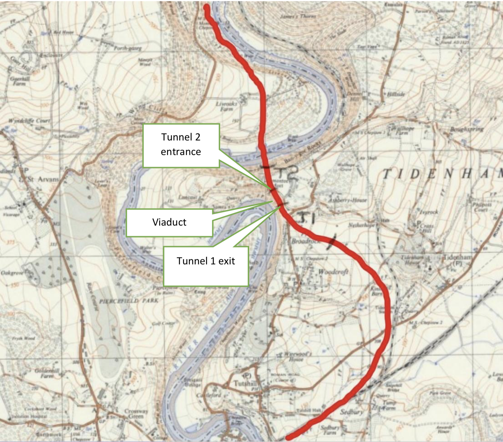
Fig 2: The 1865 route is in red.
T 1 tunnel is 715 yds long. T2 tunnel is 249 yds long. The 1865 route follows the Wye to join the 1874 route near Tintern Parva.
(maps.nls.uk/index.html CC-BY-NC-SA)
More detail of the 1865 route to Tintern Parva is shown in Figs 3 and 4. Fig 3 also shows the location of Wye cottage that was lived in for many years by the Sydney Yockney the Resident Engineer and his descendants.

Fig 2a: 1865 route in red.
1874 route in black.
(maps.nls.uk/index.html CC-BY-NC- SA)

Fig 3: 1865 plan showing the departure point from the South Wales Railway, the two tunnels and the river Wye crossing. Fig 9 shows a photograph of the position of the tunnel exits and entrances and the viaduct.

Fig 4: 1865 plan from the Liveoaks river crossing (top left) to Tintern Parva.
Reason for the change the railway alignment from the west to the east bank
The only explanation we have found comes from a WVR special board meeting of 12 February 1875. This simply stated that the new route ‘would probably be more economical’ 1. Not exactly evidence of an in-depth analysis.
For this reason, we have made comparisons between the two plans to find the missing evidence.
Comparisons between the 1865 plan and the 1874 plan
Approximate Length comparisons
1865 plans
Length: 14 miles 4 furlongs 1 chain equivalent 14 miles 902 yards.
1874 plans
Length: 13 miles 3 furlongs equivalent to 13 miles 660 yards. Plus 4 furlongs 2 chains equivalent to 924 yards for the Wireworks branch. Total 13 miles 1584 yards.
The 1874 route is approximately 1078 yards shorter than the 1866 route.
This difference is approximately the same as the extra length of the 1865 line as a result of the WVR leaving the South Wales Railway just after the Chepstow bridge instead of further to the east in the 1875 plan. This adjustment has nothing to do with the change of route to the west bank of the river up to Tintern. If an adjustment is made for this then there is little difference in the length of both routes.
Tunnel length comparisons
1866 Act - from sections:
Two tunnels: 249 yds + 715 yds = 964 yds plus one viaduct between the tunnels of approximately 150 yards 1875 Act: Tidenham as built in 1876 approximately 1120 yards + Tintern 182 yds =1302 yards.
Difference in length: the total length of the 1874 tunnels are 338 yards longer than the 1865 tunnels. If the 1866 viaduct was replaced by additional tunnelling then the difference would be approx 188 yards (approx 15%).
The southern portal location on the 1874 plan is shown in fig 5. The northern portal was in the same location on the plan as it is today.

Fig 5: 1874 route showing start of Tidenham tunnel before the Netherhope cutting was arched over. Netherhope bridge is shown a short distance to the left.
The 1874 plan was altered slightly during construction at the southern end to include a short extra tunnel where the southern portal is now, followed by a cutting leading to the southern portal on the 1874 plan. The short extra tunnel can be seen on the 1880 25 inch to the mile map (Fig 6). Between 1900 and 1919 the cutting was arched over resulting in the continuous tunnel seen today 2.

Fig 6: Short second tunnel shown on the 1880 25 inch to the mile Ordnance Survey map.
(maps.nls.uk/index.html CC-BY-NC-SA)
Fig 7 shows a measured section3 of the tunnel marking the southern portal as located on the 1874 plan.

Fig 7: Measured section from Greenways and Cycleroutes planning application on which a black dot marks the position of the south portal on the 1874 plan
Bridges across the River Wye comparisons
1865 - 2 bridges:
Redbrook and from Lancout to the Livox peninsula.
The bridge/viaduct across to the Livox peninsula could have been up to 700m long but it is difficult to tell from the plans (Fig 3 and 4) and sections (Fig 8). There are three references to a bridge in this location on the plans/sections which don’t seem to be consistent with each other and are difficult to read. Resolution will need to wait until a further visit can be made to the Records Office. Scaling from the section indicates a length of viaduct and bridge of around 500 yards.
1874 - 3 bridges: Redbrook, Tintern, Wireworks.

Fig 8 Section of 1865 route between Tunnel 1 and the Livox peninsula.
1865 route between the two tunnels
We have found no information about the WVR intentions of the route between the two tunnels. Jeremy
Cowen, Greenways and Cycleroutes volunteer has come up with a tentative conclusion. He knows the area well as a climber. This is a summary of his findings so far:
‘Tunnel 1 (Fig 8) appears to exit from a vertical cliff face now known to climbers as 'North Wall'. The first attachment indicates this location and the direction of the line to the left. The line then re-enters the cliff face after approx. 150 yards at the point shown in Fig 9. The only practical option between exit and entry seems to be a viaduct which would not be out of the question for Victorian engineers. It would afford a magnificent view of the river Wye and could have enhanced the reputation of the engineers. It is assumed that a continuous tunnel was not chosen on grounds of cost.’
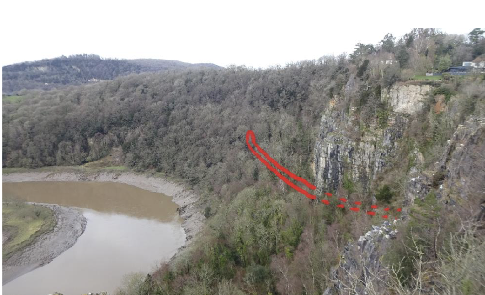
Fig 9: Tunnel 1 exit on the right not far from Wintour’s Leap. The dotted lines show the location of Tunnel 1 before the exit. Tunnel 2 entrance is on the left. The solid line is the route of the railway between the two tunnels.
(Jeremy Cowen)

Fig 10: Tunnel 1 exit from Wintour’s Leap.
(Jeremy Cowen)
The northern portal of tunnel 2 is situated on the northern side of the Lancaut peninsula in the midst of another set of cliffs known Ban y Gor.
Comparison of routes after the northern tunnel exits
On the 1874 route there is a long shelf with embankments and a three-span viaduct leading to the Tidenham tunnel. There may have been a similar complexity on the 1865 route.
Summary of Differences
Length: Little difference resulting from routing the line to the east bank of the river.
Tunnels: The 1874 route has approximately 170 yards of tunnel (15% extra) assuming the 1865 route was modified to provide a tunnel between T1 and T2 This is approximately the length of the Tintern tunnel. Tunnels are by far the most expensive feature to build so this is a significant cost difference.
Bridges: One additional bridge on the 1874 line but as the Lancaut bridge on the 1865 route could be 500 yards or more long the total bridge cost of the 1865 route could have been more than that on the 1874 plan.
Wireworks branch line: This contributed to extra track length and bridge count for the 1874 plan
Income: The Tintern station on the 1865 plan could have been positioned closer to the centre of population and so attract some additional traffic.
Complexity of construction:
The access to the 1865 tunnels during construction in the two locations, where they entered the cliff face, would have been very limited. An extra deep shaft may have been needed for both tunnels to remove spoil and for access. It would have been possible to drive a single tunnel without leaving and re-entering the cliff face but the alignment could have resulted in a longer tunnel than just the 150 yards between the two tunnels on the plan. The foundations for the viaduct could have been a problem unless solid limestone bedrock could be located.
The 1865 route goes right through Tintern so there could have been local objections. It also passes close to the Abbey. This risk of damage to the Abbey was raised by a House of Lords select committee. Although the solicitor for the Duke of Beaufort gave assurances that there would be no risk it is quite possible that there were second thoughts about this. One possibility is that the Church and maybe influential local residents could have been behind the House of Lords query about the risk of damage and could have continued their objections after Parliamentary approval to the 1865 route.
As the 1865 route passed through Tintern there could also have been further vocal objections from residents.
From the available information it seems that, even if cost estimates of the two routes may be similar, the risks associated with the 1865 route could easily have resulted in extra cost and time.
If there was little difference in the cost of the two routes, then company directors could have been well advised to adopt the route with the least opposition. The statement at reference 1 about the revised route probably being more economical lends some weight to there being other factors influencing the decision.
More information could be available at the National Archives at Kew through viewing document RAIL 10751220 which includes an ‘Engineers report and estimate of traffic’ in the year 1874. Unfortunately, this is not available on-line. The Institution of Civil Engineers has been approached to see if they hold personal records of the Engineers for the line, Samuel and Sydney Yockney, but unfortunately there are none of these documents in their archive. We have also located Iain Langston Yockney, a descendant of Samuel Yockney who holds the family records. Iain has provided a number of records so far, but none yet shed light on the decision to change the route of the line. There are more records to be retrieved.
We now probably have enough evidence to understand the rationale behind the decision even if we have not yet found contemporary supporting documents.
References
2 Feb 1875 Special WVR Meeting - Western Mail 13 Feb 1875.
From OS 6 inch maps of 1900 showing the cutting and 1919 showing the cutting arched over to create an extension to the tunnel.
Additional notes
Additional note on tunnel length
The start point of the 1866 tunnel is shown in Fig 5.
The length of the present day tunnel can be confirmed by referring to Fig 6 where the current tunnel starts at 1 mile 35 chains and finishes at 2 miles 9 chains or 1188 yards. The tunnel was extended at the southern end by approximately 70 yards between 1909 and 1919 2. So, the original length was approximately 1120 yards.
A tunnel length of 1120 yards is also recorded in the Monmouthshire Beacon when reporting on the opening of the railway. In the 21 Oct 1876 article in the Bristol Mercury and Western Counties Advertiser a length of 1100 yards was mentioned when reporting on the opening of the railway the previous day. The discrepancy of 20 yards may simply be that the Bristol Mercury rounded down the figure.
Additional note on the third set of plans
A third set of plans is kept at the archives for 1875 (Ref: Q/RUm/407) These show some minor route additions around Chepstow station: Redbrook industrial area: at Wyesham missing out the Wye crossing to Troy station and joining the Monmouth to Ross line just after that line had crossed from Troy station and a road crossing at Brockweir that was not built until the early 20th century.